FEMA draws ire of property owners, county with new flood maps


Gonzales County commissioners expressed concerns at a Monday, June 24 meeting about a new flood plain map of Gonzales County by the Federal Emergency Management Agency (FEMA) which seemingly puts a number of properties in the 100-year flood plain — including the Gonzales County Courthouse.
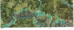
Dale Koehler, who owns 39 acres of land in Belmont with frontage access to US 90-A between property owned by the Wundt family and the Ford family, told commissioners that the new FEMA flood plain map inexplicably puts elevations that never flooded in October 1998 — during a 500-year flood event — in the 100-year flood plain.
The new flood plain map, which was published on March 27, 2024, includes 560 acres out of 600 acres of property owned by his family, the Wundts, the Fords and the Goss family at the southeast corner of US 90-A and Texas 80.
“(US 90-A) is 361 feet at the pavement edge. And in 1998, which is considered the 500-year flood, the water was at that pavement edge and did not go over (US 90-A),” Koehler said. “The new FEMA floodplain, which is the 100-year FEMA floodplain, is now three and a half feet over Alt-90 and goes up the hill on the other side.
“You know, we can't have a 100-year floodplain that's three feet higher than our known 500-year floodplain. That doesn't make any sense. Logically, it's incorrect.”
Koehler said he believes engineering firms brought in to do mapping for FEMA just “made assumptions” about the area without doing any historical research about whether the area was prone to flood in the past.
Even more importantly, Koehler stated he believes FEMA ignored its own “very specific” process for updating flood plain maps.
“They have a four step process. It's very involved in communicating and involving the community,” Koehler said. “There was supposed to be meetings that included the commissioners court. There were supposed to be meetings that included the public that had to be posted in the newspapers; there had to be two postings. There was a 90-day appeal process. And based off of everything I've heard, none of that happened.”
He told commissioners he believes the county could use this process breakdown “to have a leg to stand on” to appeal the new flood plain map by demanding a review of the technical data used in the decision making process to determine if a mistake was made by FEMA.
“I'm just asking the court to please consider taking action on this. I know it's just a discussion item today but taking action to direct (Emergency Management Coordinator Jimmy) Harless and/or whatever we need to do,” Koehler said.
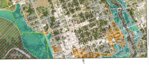
Gonzales County learned the Gonzales County Courthouse will now lie in the 100-year flood plain according to the new FEMA map when it applied for a grant from the Texas Historical Commission to renovate the courthouse. However, the Gonzales Fire Department, located just north of the courthouse on Saint Lawrence Street, as well as the Methodist and Baptist churches on Saint Paul Street, are considered out of the flood plain.
“No one told us anything other than when we were applying for the Courthouse grant, and all of a sudden, we’re told ‘you’re in the flood plain,’” County Judge Pat Davis said. “We’re in the flood plain, but the (Gonzales) Fire Department is not. I feel your pain, but let me see if we can figure out something to resolve this or what we can do.”
Davis said he had spoken to Richard Goss, owner of Diamond A Convenience Store in Belmont, which is located across Texas 80 from the farmland in question, and was advised that three generations of the Goss family had lived in the area and never seen flooding in the area which FEMA had moved into the flood plain on the new maps.
Koehler responded that Goss, who could not be at Monday’s meeting, had told him he had to purchase flood insurance and as a result, prices have gone up in Diamond A to offset that cost.
“This bviously affects valuations in the area,” Koehler said. “It's going to mean a lot more work for the county as far as permitting. Somebody has to run all those permits that are now going to be required on all this land.”
The Koehler family built a barn and pavilion on their property and he hopes his son, who enjoys hunting and fishing on the property, will be able to build a house there someday.
“We have the hill where he could do that, and not be in the floodplain,” Koehler said. “But as of now, they've raised (the flood plain) so high, we went from not being in the floodplain to where, if you wanted to build on there, you'd have to build a coast-type house about 12 feet above ground that doesn't flood.”
Harless said the flood maps, when he finally saw them, left him at a loss for words.
“I’ve seen the elevations that Mr. Goss provided to me in my office for the store and Mr. Koehler’s good description of what's going on out there,” Harless said. “I think what (FEMA) did was hire some engineering firm not from the area.
“They're looking at aerials. I don't know if they were ever on your property; I'm assuming, you would know if they had been. And they just put a bunch of numbers into a computer and it spit it out and that's what they go with.
“I don't think there's any common sense applied to it,” Harless said. “I don't think there's any reasoning apply to it. And then, unfortunately, now we have to try to help the property owners out there on this ridiculous elevation that FEMA dropped on us.”


Comments